
The QGIS Live Map image source streams your current QGIS map onto a surface, using the Geoscience plugin’s Spatial Integration Link. Whatever the QGIS map canvas shows — layers, edits, symbology — appears on the surface and refreshes as you change it in QGIS.
Setting up the link
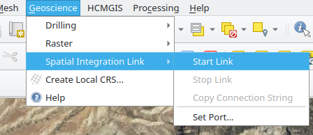
- In QGIS, open Geoscience > Spatial Integration Link > Start Link.
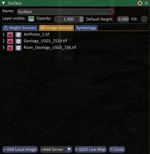
- In Spatial Integration, the QGIS Live Map source already exists, just click the button in the Image Sources tab of the Surface dialog to add it to your surface.
If the map does not appear
A warning icon next to the image source name means Spatial Integration cannot reach the QGIS tile server. Check each of these:
- QGIS is open and the project you want to see is loaded.
- The link is started: Geoscience > Spatial Integration Link > Start Link. The menu shows Stop Link when it is running.
- The port matches. The port in the source URL (the
8089inhttp://127.0.0.1:8089/...) must be the same as the port the plugin is listening on. Note the port that QGIS is serving on by selecting the "Copy Connection String" or "Set Port" menus. Then, set the source’s port in the Image URL text box in Spatial Integration under Configure (Streaming tab). - If you need to set the port manually, use the Geoscience > Spatial Integration Link > Set Port… menu, and set the same port in Spatial Integration under Configure (Streaming tab).
- If you have a layer in QGIS that takes an excessive time to render it can time-out the tile requests. Uncheck large layers to find which one is causing the problem.
The warning clears automatically within a second of the link becoming reachable again.
Keeping in step with QGIS
Turn on Refresh automatically when the QGIS map changes in the source settings so that turning layers on and off, editing, or restyling in QGIS updates the surface without a manual refresh. The refresh will happen within a second or so.