
Packaging a project is a convenient way to gather all your data files together along with the project file so that they can be easily transferred to someone else. Typically, you zip the entire package directory structure before sending it so that it can simply be unzipped and opened in Spatial Integration at the other end.
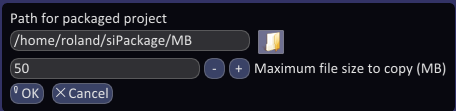
Specify a directory to put your package. This should be a newly created directory specifically for this package. Note that you can create a directory by using the plus button at the top of the file dialog.
Specify a maximum file size to copy. Spatial Integration can handle elevation grids and overlay images of hundreds of gigabytes in size and these would usually be excluded from the package. If a data file exceeds the maximum size limit, the layer information will still be included in the Project file and the package directory will still be created. This way, if the receiver already has a local copy of the large file then they can copy it into the correct place in the package directory structure and it will be used just as if Spatial Integration had packaged it.
Overview (*.ovr) files for large raster grids and images are excluded from the package. These will be recreated by Spatial Integration the first time the packaged project is opened.
Remember to check your log messages for notices that files have been excluded.